Meanwhile in Ireland

Ambiana and Jakobi continue their adventures in Ireland, heading to Galway for a weekend by themselves!



Meanwhile in British Columbia

Colleen flew out on Thursday for Victoria Island in BC for a four day hike along the Pacific Coast before meeting up with Debbie, Anne and Stacy for a girls week in Canada. She found some Kombucha! and her hostel is the blurry building in the background.
Meanwhile in Vermont

Gaelen & Heather enjoyed a beautiful day on the waterfront in Burlington. Those are Gaelen’s toes in the Birckenstocks!
Meanwhile in Maine….
Mt Desert Island Field Study June 26th-June28th 2024
I left after work at 7pm on Tuesday and drove East along Rt 2 into NH and on through the night into Maine along state highways. Saw very little traffic until I came to I-95 around 11pm. I joined the northbound traffic and around 12:30am I pulled into a rest stop outside of Bangor and climbed into the back of my truck and slept.
Field Study Day #1 – The Beehive -Gorham Mt- Sand Beach – June 27th 2024
Awoke around 6:30am and continued on to Mt Desert Island, stopping once to buy peaches for a peach cobbler dessert I have in mind to cook in the Dutch Oven later today. The skies had cleared and in the near distance as I approached Mt Desert Island I could see the glacially sculpted ridges of Acadia National Park. I made a quick stop at the visitors center which provided no info or maps just hordes of people in line for the park pass which foretold of the crowds to come. I thought I was getting here early (8:30am) but evidently so did everyone else. As I drove the park loop road towards the Precipice Trail I could see that all the pull offs were already full of cars. I spotted the parking lot for the Precipice Trail and to my relief it looked relatively empty but then I saw that it was closed for Peregrine Falcon nesting season. At the Park Entrance Station I was told the Beehive Trail was open and I could park at Sand beach. I started seeing cars pulled off on the right side of the road before I came to the parking lots which had a “LOT FULL” sign prominently displayed. The parking on the right seemed to extend indefinitely down the road and I drove maybe ½ mile before the car in front of me pulled over and extended the line with me extending it further as I parked and immediately in front of me car after car pulled over and parked. People were walking in both directions on the path along the ocean. Up and down the line of cars people were getting out; young couples, families with little kids, older folk like me. Everyone getting their gear together, applying sun block, fitting water bottles into packs.

I joined in, getting into my hiking clothes; light weight long sleeve shirt and pants, hat, sunglasses, pack with water, snacks, weed and my field notebook. In my haste and excitement to start the hike I forgot the binoculars. I joined the masses on the ocean path; people returning from the Beehive hike, others headed to Sand Beach, others like me heading for the Beehive. The hike started from the loop road in a beech and evergreen forest littered with glacial erratics and stone plucked from the southern face of the granite know known as the Beehive which we were to ascend. I had planned on finding a nice rock and smoking a bowl but before I could do so I came to the junction for the easy way up and the rung and ladder route and realized it was probably best that I waited till the ascension was complete. The route got steep pretty quick as we were ascending the steep plucked southern face of the Beehive the trail climbing benches that gave long views out over Sand Beach to the East and Gorham Mt to the South.

The trail was wide, the exposure great and the drop long and precipitous. It was no trifling affair; the views were vast, the cliff face steep, the ledges sidewalk wide and well worn. There were iron rungs and handrails neatly placed to assist at the sidewalk-less spot. As we got higher the line of hikers backed up at the pinch points where iron rungs and railings embedded in the rock help hikers navigate the trickier and steeper pitches. It brought to mind the pictures I have seen of the long line of climbers on Everest below the summit. Up ahead adding to the delay a family of five with three children who all looked younger than seven were very slowly and very carefully making their way up; the dad shepherding two boys and the mom doing the same with a very young girl wearing a panda-faced backpack. They were doing well and there was no need to rush as there was no place to pass or step aside and even if there was there was no end to the people ascending so all that they could do was to get at it. The line of hikers behind was good natured and friendly bantering to each other as we waited. We could not help but take in and appreciate the magnificent views we would not have been afforded had we been scampering up lickety-split.
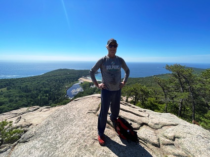
The tricky areas were not very many and before long I was up on the beautiful exposed glacially rounded smooth granite of the Beehive Summit taking in the 360 degree view. The trend of the ice sheet that sculpted this rock is evident in the shape of the mountains to the West and the small rounded islands that dot the coast to the East. The course of the ice clearly shown in the shape of the rock, islets and inlets all sparkling in the bright June sun. Just off from the summit I found a small copse of dwarf pine and beech with a large glacial erratic where I took a seat and smoked that bowl before rejoining the line of hikers headed down the Bowl Trail passing shortly by a small pond, which once was the font of a tributary glacier flowing over these rocky ridges to the sea and is now a depression such as a snow angel made by a child, filled originally with ice melt and kept filled by rainwater and enduring reminder of the force that has shaped this land.

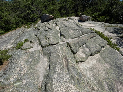
From the pond I hiked up to the summit of Gorham Mt where the forest fell away and the massive granite rock lay exposed as if surfacing. The exposed stone revealed parallel lines of striations grooved into the granite. Evidence of the massive glacier that once covered this island as well as most of North America. Rocks caught in the underside of the ice sheet and subject to the immense pressure and weight of the ice sheet carved out lines in the granite as the glacier inched it’s way towards the sea. I examined many sets of striations and also saw evidence of water eroded features. As the ice melted a wide river ran continually beneath the ice sheet; melt water working it’s way down over the rock buffing it into watery slopes and curve a process continued to this day with each rainfall.

Twenty thousand years later and it is a glacier of people covering the island. I knew it would be crowded but this is way more people than I thought would be here but should have suspected. I did not have a map nor take a picture of the trail map at the trail head so I chat up the hikers I meet up with, there are plenty of them to secure my route down the mountain which basically follows the gently slope of the southern ridge back down to the coast. Along the way I find ledges and benches with tumbled rock at their bases; evidence that the rock I am descending was once submerged below sea level by the weight of the ice sheet upon it allowing the sea and wave action to pluck at the rock and form short sea cliffs that have rebounded to this present altitude since the ice sheet melted.
I gathered a small sample of the cubic granite sand that accumulates in small pockets upon the rock. I suspect this may be glacial till but it is most likely dross; recently eroded remnants of the surrounding rock. I also collected a small buffed piece of eroded granite. It is grayish pink, worn and weathered with smooth soft edges, I would like to think it was buffed and smoothed by glacial action but it is most likely erosial, maybe even a remnant of the trail building process. Homo Sapiens have supplanted the glaciers and are now the greatest geologic erodal force on the planet. The rock fits nicely in my palm and brings me comfort to carry it as I hike. This rock is older than anything I own, its older than anything I know. A billion years in the mantle down near the core uplifted extruded as lava eroded away to seafloor, metamorphosed, thrusted, folded and uplifted into mountains worn away again to seafloor, subducted in a deep ocean trench and crushed so hard it becomes molten again. Such is the life-cycle of the rock in my hand.

The whole hike up the Beehive, across the Bowl to Gorham Mt and down to the coast was just over three miles and the trail ended at a parking lot that was full letting out onto the loop road with cars parked on the right as far as you could see in both directions. I crossed the road to the Ocean Trail that would take me back to my truck and on to Sand Beach. There were numerous little trails leading to the granite benches falling into the sea and I ducked down one of these and sat on the warm stone overlooking the bay and the sea. Across the bay I could see the rocky headland and Sand Beach in its embrace, the sand dotted with people and and the line of waves bobbing with the heads of swimmers. All up the coast the granite benches tumbled into the sea washed by sea and surf and all over the rock were clumps of people sitting, standing, walking, crouching and a few even attempting to swim off these rocks. I was hot and was looking forward to getting into the sea myself so I rejoined the throng walking the Ocean Trail and began to recognize some of the faces I had passed going the other direction on Gorham Ridge and an older couple whom I had stopped to chat with on the ridge about trail directions smiled and said “You made it” as we came across each other again here at sea level.
Back at the truck I grabbed my suit , exchanged my trail shoes for sandals and put a print out of THE GEOLOGY OF MOUNT DESERT ISLAND .BY F BASCOM Reprinted from THE BULLETIN OF THE GEOGRAPHICAL SOCIETY OF PHILADELPHIA, Vol . XVII , No. 4 , October, 1919. in my backpack and headed down to the beach where I refilled my water bottle and then descended the steps to the beach which was filled with people laying in the sun, kids playing in the sand, people frolicking in the surf, walking the edge of the marsh backing the beach and climbing the forested rocks that made up the headland on the far side of the beach.
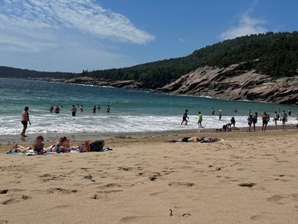
I found a bare spot of sand and set down my chair. The sun is bright overhead and hot. If it is the sacred I am seeking on this field trip then the sun is the first sacred thing and foremost. Our magnificent star filling our world with light and warmth. Without the sun we would not be. There is a swell coming in as the moon now set below the western horizon, is tugging upon it causing waves to rise and break on the incoming tide. The water is cold and I do my wade in wade out wade deeper, wade out to acclimatize myself and it works and soon I am surfing the waves with my body catching short swift rides up onto the beach which more often then not leave my suit around me thighs. A gaggle of young ladies is doing the same near me attempting to ride the surf, laughing and throwing seaweed at each other. The Ocean is the second sacred thing. It took life 2.5 billion years to coalesce in the Precambrian Seas and another billion years to emerge from the Ordovician Seas onto land. Homo Sapiens are pulled to the ocean by unconscious tides of deep memory and remembering.
I catch my fill of waves then retreat back to my chair where I change into dry clothes and turn my back to the sea and the sandblaster breeze and read up on THE GEOLOGY OF MOUNT DESERT ISLAND .BY F BASCOM. She wrote this before plate tectonics were a thing but she obviously was familiar with glaciated land forms. Her observations of the the benches and ledges at elevations above sea level led her to deduce that the land had been submerged as only action of the sea could create such features as there is no evidence of earthquakes due to the precarious nature of many glacier erratics that would most certainly have been displaced with such earth movements.
The granite of Mt Desert Island is an immense upwelling of magma into a preexisting sedimentary layer of eroded rock and volcanic basaltic flows. The magma forming bubbles and forcing it’s way into every crevice it can find in the preexisting rock and creating crevices where there is weakness. The granite lay under these layers of lava and eroded mountain rock rivered out to become seafloor which in the long long reach of time weathered away leaving the more resistant granite to be sculpted by the massive ice sheets that periodically overspread the continent, the land submerged and lifted as sea level rose and fell all conspiring to create the marvel that is Mount Desert Island which is to some extent still partially submerged and gradually uplift.

Field Study Day #2 – Cadillac Mt – June 27th 2024
Hiked about 9 miles today from the campsite to the 1500′ elevation of Cadillac Mountain; highest mountain on the Eastern Seaboard and the only one with a road to the top. I had a mellow morning in camp starting out around 11:45am. At first it was a gradual climb beginning in forest thinly rooted in the few inches of soil sitting atop the granite. The whole trail was on granite; granite paths through the trees worn smooth by footsteps and when the trees were left behind broad swaths of granite all the way to the top. There were no brooks or streams, just bristle cone pines, beech, birch and smaller vegetation. As I climbed higher on the slope glacial erratics, plucked stone and eroded boulders lay scattered throughout the forest. Though there was no running water I was following the path of down-flowing water made evident by the shape and contours of the rock. It rained overnight and into the morning so there were damp traces of the flow of rainwater as well as pockets of standing water in hollows and depressions; liquid islands in a stream of stone.

A spur trail to Eagle’s Crag led to a swell of exposed ledges facing the East. Evidence of submersion per R. Bascom they suggest cliffing due to the battering of ocean waves. The view took in ridges and the sea; I could see the Beehive and Gorham Mt and Ridge. Today I had remembered the binoculars and I watched the small figures of distant hikers traversing the ground I covered yesterday.

As I left the forest behind for the exposed granite of the ridge I began to encounter people presumably hiking down from the parking lot at the top. I could also see into the deep narrow valleys on both sides and the bodies of water contained within. That they are glacial formed there can be no doubt, polished pockets of granite dot the sides of the ridges and the lakes and ponds; the distant cousins of the one mighty ice sheets now take their place.

The granite is glacial smooth all around me as I hike on, striated and covered with erratics, till, dross and drift with colorful lichens in all shades covering vast stretches of the rock with grasses, mosses and small trees endeavoring to transform the landscape like the forested lower slopes. It is a vast sea of stone scrubbed smooth by ice as the glaciers moved through. Puddles from last nights rain abound making clear the influence of ice melt and rain water on the eroded stone. Here was a very cold world of ice and water for a very long time.

If I were here on this ridge rock 20,000 years ago how much ice would I have to tunnel through to reach the glacier’s surface and would the sea I see be a frozen white world as well and closer with the land depressed by the weight of the ice upon it? All I would see would be a white world of ice and sea and now look at all that is here; boats out in the channels, houses dotting the islets, peninsulas and shores. Roads, a cruise ship, a road to the mountain top and everywhere on every ridge I can see people, people everywhere. Descending the ridge toward me, all around me, some heading up with me.

At the top there is the road and two parking lots, a gift shop with a water refill station and a ½ mile paved loop around the summit filled with people. I walked with them the ½ mile loop admiring the views not get all Edward Abbey-ish begrudging my fellow Homo Sapiens having climbed to the summit in the ease and comfort of their cars. It is enough that they are here summoned by such a stunning display of Nature to be touched by wonder and a momentary awakening from the slumber of the present times.
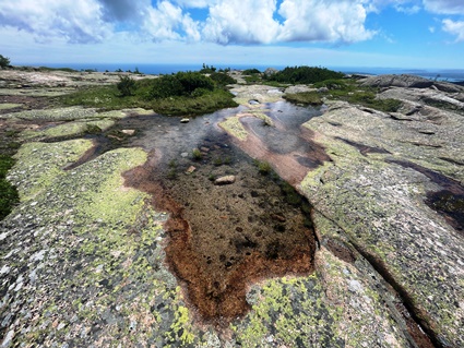
On the way back down I lingered at some powerful spots to sit in the now and be here. Rocks such as the one I am sitting one are the third sacred thing. People hike for the views; the span that can be seen brings wonder and awe but little do they know of the depth contained in the rocks beneath their feet. To them it is just the roadbed that brought them to the top. Some rocks, like the lava spewing forth right now in Iceland & Hawai’i are young but for the most part rocks, like the rocks beneath my feet here on Cadillac Mt are old. So very very old. Half a billion years! It is a very hard thing for us to comprehend just how vast a stretch of time that is. Homo Sapiens have been doing its thing for 50,000 years and we think that is a long time but Australopithecus spent 2.3 million years doing its thing; that’s 50,000 years stretches 50 times in a row. We marvel at the brief life of a fruit fly wondering how they squeeze a lifetime into three days but to the rocks all around me it is we who are the fruit flies. It is this depth that is contained in the rocks that add meaning and purpose and give direction to our postmodern meaningless lives; a sense of the self as the guardian of a sacred emergence that has been playing out over billions of years and is recorded and evident in the rocks all around us.


I make my way slowly down stopping to collect samples and take pictures of the granite intrusions and striations, heart shaped puddles and stones…

until I am in the forested lower slopes again where mosses and grasses are making tiny biomes atop glacial erratics.

I come to ledge at 630′ of elevation evidence of a long ago sea shore uplifted upon the retreat of the ice. These sea level benches occur at 270 feet, 340′ feet and 480 feet above sea level and some ill defined above 1000′ revealing how active the rock is on a scale of deep geologic time. I stop briefly again at The Eagle Crag bench for a snack before returning to camp at 5pm

Field Study Day #3 – The Bubble Route – June 28th 2024
Today dawned sunny, had an unhurried morning, made tea and breakfast and headed off to the Bubble Trail at 9:15am rejoining the loop road where I left it two days ago. The road led up one of the islands nine parallel narrow valleys along the shore of Jordan Pond to the Bubble parking lot which was full. I pulled in, positioned the truck behind a full line of parked cars and waited and soon a couple emerged from the woods with a baby in a carrier and the lights of the car directly in front of me blinked on. In no time I was parked in the space they vacated and packing my day pack for my field study day.

I took a picture of the map at the trail head and then studied it and determined I could hike down to Jordan Pond then up the trail to the South and North Bubbles and then beyond them down a long sloping ridge to Eagle lake and then loop back along the lake to the parking lot. Maybe four miles in all. The Bubbles are glacial sculpted domes all plucked on their south facing sides with the plucked stones scattered willy-nilly in the forest which is pine and birch.

It was a short walk to Jordan Pond which had a perimeter trail around it full of people making the circuit.


The South Bubble and Bubble Rock trail ascended moderately steep from the head of the pond winding up through large erratics and plucked stone warmed by the sun.

Once out of the trees I emerged at the top of the South Bubble, a large glacial scrubbed granite monolith or ‘bubble’. As always lots of people up top and more coming from both directions on the trail. The view over the pond to the sea was expansive and beautiful as were the parallel granite ridges of Pemec and Penobscot Mountains on either side with Cadillac Mountain also visible to the Northeast. I scanned the ridges with my binoculars and could spy people at the summit of Penobscot Mt as well as cars ascending the road to the summit of Cadillac Mountain.
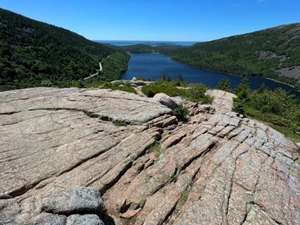
The pond below is all that remains of the ice that sculpted all that I see, filling the bowl excavated by the glacier first with it’s meltwater and replenished by millennia of rainfalls. The forested remains of the glacial moraine at its farthest terminus is visible as well as two distinct channels eroded on either end where the meltwater flowed into the sea.

The sides of both Pemec and Penobscot Mountains feature large patches of glacial polished granite with mineral stains made by rainwater flowing down their sides. On the top of the bubble the granite shows the usual sculpting of both ice action and ice melt, the rock both striated and worn and rounded by the volume of ice and water moving over it.

A short path from the summit led to Bubble Rock, a large glacial erratic perch precariously on the edge of a cliff. A close examination of the rock reveals it to be a puddingstone; a conglomeration of smaller stones and quartz cemented together with glacial grist and metamorphosed by the extreme pressure of the weight of the ice sheet upon it.


The cliff edge it is perched on shows signs of sea cliffiing by wave action further evidence of the submergence of Mount Desert Island also due to the immense weight of the glacial mass.

The trail continued down off the South Bubble onto a short forested saddle before a short steep ascent to the North Bubble which shows all the tell-tale signs of glacial action as the South Bubble.

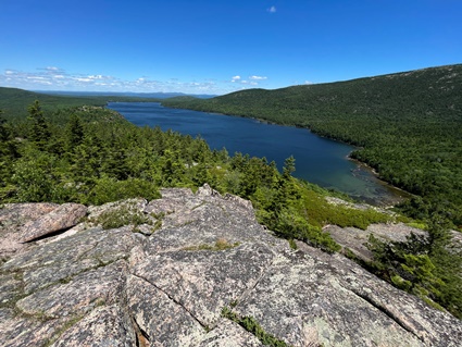

The trial then followed the ridge down a gentle mile long slope affording many views of the surrounding mountains and Eagle Lake below. Gazing back up the broad expanse of granite reveals both bubbles to be the most resistant of the rock in the path of the glacier which carved the rest of the rock into a steep narrow valley and beds for the lake and pond on its way to the sea leaving the polished granite domes of the bubbles rising up out of the valley between the two bodies of water.

As Eagle Lake is approached the forest turns primarily pine and the loop back along the lake shore is a jumble of pine needle covered erratics and plucked stone that make the going slow but picturesque until the head of the lake where the forest contains a mix of pine and birch and the trail follows a gentle rise out of the lake filled depression carved by the glacier back to the parking area where I began the hike.

I drove back around the Park Loop to the Nature Center where I took a nice walk on a boardwalk and became an Acadia National Park Junior Ranger
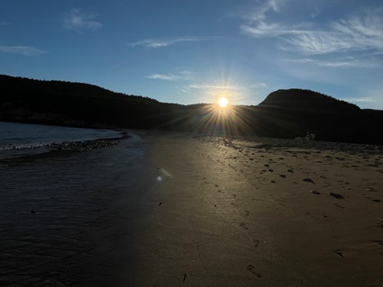
I finished the day at Sand Beach, cooking dinner in the parking lot and hanging on the beach for sunset. On Saturday I had planned on stopping at Lower falls in NH but the rainy weather spurred me home where I hugged the cat and bunny, hung with Gaelen and Heather and took a most relaxing bath.